


The Meadowlands is a unique estuary ecosystem in northern New Jersey, just west of New York City, where the Hackensack and Passaic rivers formed an assortment of tidal wetlands, salt marshes, and upland forests. For thousands of years before European settlement, the Lenape people lived sustainably along these waterways, relying on hunting, fishing, and gathering while maintaining a balanced and sustainable relationship with the natural environment. This balance shifted with Dutch colonization in the 1620s, as native communities were displaced and large-scale drainage, deforestation, and infrastructure projects transformed the area for agriculture and industry. The arrival of railroads and the growth of port towns further altered the marshes, leading to increased resource extraction, suburban expansion, and widespread dumping that continued into the twentieth century.


The Meadowlands District is a 30-square-mile geography situated a few miles from New York City.
Relationship to the Broader Metropolitan Area
Today, the Meadowlands District is at the crossroads of maintaining major transportation routes, key industrial and economic hubs, and regional entertainment venues, while expanding ambitions for ecological preservation and climate adaptation. Its proximity to the New York-New Jersey metro area makes it a prominent corridor for regional travel, as major transportation routes such as the New Jersey Turnpike, the Amtrak Northeast Corridor, and New Jersey Transit rail lines link population centers across the wetlands. It is also a hub for goods logistics and transportation, providing essential connections between highways, rail, and port terminals. While most visitors and goods travel through the District, popular destinations within the Meadowlands include the world-class MetLife Stadium, the metro area’s largest entertainment venue, and the American Dream Mall, the second-largest mall in the U.S.
In addition to important infrastructure and prominent commercial development, the Meadowlands contains the largest remaining complex of brackish tidal wetlands in the New York-New Jersey Harbor Estuary, serving as an irreplaceable urban sanctuary for endangered species, a major segment of the Atlantic Flyway for migratory birds, and as a vital ecosystem for services like natural water filtration. The expansive wetlands that support biodiverse wildlife also provide unparalleled natural flood protection, buffering both New Jersey communities and New York City from storm surges and rising seas.


The Meadowlands District
The NJSEA Meadowlands District features a distinctive geography that encompasses portions of 14 municipalities across two counties and is bisected by the Hackensack River. Major roadways run through the District, but local street access is relatively limited. Rail transit similarly prioritizes east-west movement, with only two stations: Secaucus Junction, a major transfer point for passenger services, and Meadowlands Sports Complex Station, which serves special-event trains for MetLife Stadium. The primary land uses by acreage in the District are wetlands, transportation, and industrial developments, creating a contrast between large-scale urban development and the surrounding natural wetlands.
Land Use within the District 2018
Source: New Jersey Sports and Exposition Authority (NJSEA) 2020 District Master Plan


The NJSEA emphasizes that “economic growth and preservation go hand-in-hand.” Since the District’s establishment, the amount of open space and parkland has increased significantly, growing from 24 acres to over 190 acres of recreational land, including eight miles of trails. Notable park spaces include DeKorte Park, River Barge Park & Marina, and Mill Creek Point Park, which offer a balance of ecological preservation and recreational opportunities. Despite these successes, the eco-tourism and entertainment center offerings are often cited as two contrasting options.
The Meadowlands has two very different meanings, depending upon your interests. If you have a taste for action, the award-winning MetLife Sports Complex won’t disappoint. If you’re a nature lover, the Meadowlands is the place to explore native wetlands, birds and other animals.
(VisitNJ.org)
We’ll let you in on a little secret – the Meadowlands Liberty Region, known widely for its sports complex, industry and maze of roadways, is actually teeming with nature that’s accessible to visitors year-round.
(Meadowlands Chamber of Commerce)
However, access to District parkland can be challenging for regional visitors or those without a car, and public perception of the Meadowlands tends to sway towards sports and entertainment. Thus, there is significant opportunity to develop a more connected and expanded network of greenspace throughout the Meadowlands and to integrate ecology with other uses. In 1983, an ambitious plan for a “Meadows Path” was proposed—a 25.5-mile pedestrian trail system designed to wind around the western edge of the Hackensack River, connecting Losen Slote Creek Park in Little Ferry to West Hudson Park in Kearny. Building on this legacy, as well as the NJSEA’s ongoing commitment to expand preserves and parkland, would help create a greener, more accessible Meadowlands while strengthening the flood resilience benefits provided by the region’s wetlands.


The future of the Meadowlands needs to be rooted in a climate-forward approach that emphasizes the vital role of wetlands in enhancing regional flood resilience. As climate change progresses, the region will face rising sea levels and more frequent flood events. It is imperative that we prioritize green infrastructure initiatives, and the Meadowlands presents an exceptional resilience asset. Remarkably, one acre of wetlands can hold up to 1.5 million gallons of water, serving as a natural barrier against flooding. Hurricane Sandy vividly illustrated the devastating impact of an 8-foot inundation across the region, with much of it falling on the low-lying Meadowlands. And this incident was not isolated.
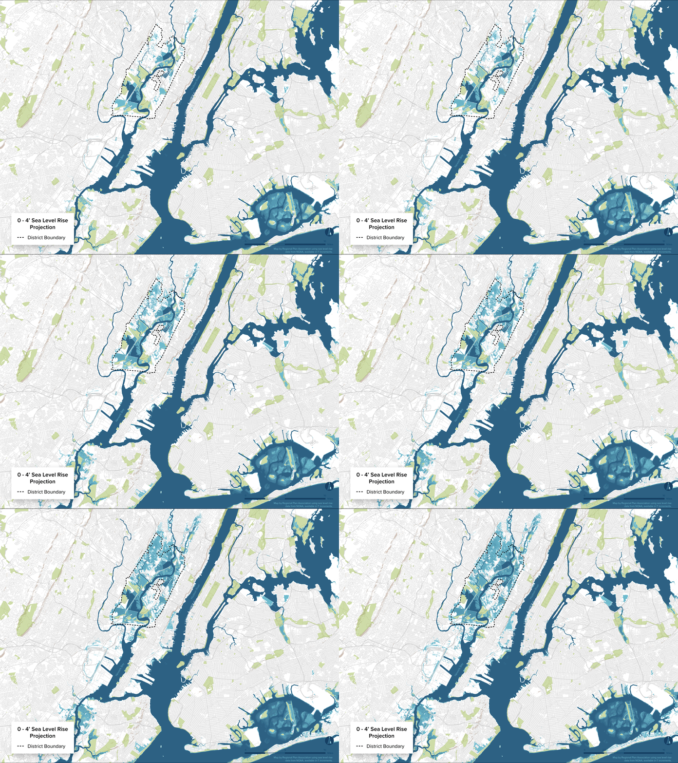
Animation illustrating a projected 4-foot sea level rise within the metropolitan area, highlighting the Meadowlands district as a major zone of inundation.
Looking to the future, intensified storms and rising sea levels present an escalating threat that will lead to the permanent inundation of various areas in the region. Rutgers estimates that New Jersey will likely see 1.3’ of sea level rise by 2050 and up to 4.3’ by 2100 under high-emissions scenarios. Furthermore, a growing body of research indicates that the pace of climate change might be accelerating. Although future projections vary across scenarios, the need to plan for a more resilient Meadowlands is increasingly clear.
New Jersey Sea Level Rise estimates above the 1995-2014 baseline (ft)
*Including or Excluding Potential Rapid Ice-Sheet Loss Processes **Excluding Potential Rapid Ice-Sheet Loss Processes ‡Including Potential Rapid Ice-Sheet Loss Processes ‡‡Including Potential Rapid Ice-Sheet Loss Processes Source: NJ’s Rising Seas and Changing Coastal Storms, Rutgers University New Jersey Climate Change Resource Center
Numerous creative plans have been developed for the Meadowlands over the years. The original 2014 New Meadowlands proposal by Rebuild by Design envisioned a flood-barrier street encircling the wetlands paired with densified development behind this protective barrier, encapsulating a “protect, connect, grow” strategy. In 2019, a collaboration between Princeton University, RPA, and The High Meadows Research Institute produced “The Meadowlands - a Climate Park”, which examined the future of 6’ sea level rise in the District. These initiatives reflect ongoing efforts to explore adaptive strategies for the Meadowlands.


Meadowlands National Park idea from RPA’s Fourth Regional Plan, 2017. Illustrated by ORG.
Value
The Meadowlands Sports Complex, a designated 580-acre site within the District, offers a strategic opportunity to meaningfully transition towards a climate preserve because it is centrally located, already draws millions of visitors to the Meadowlands, and could benefit greatly from increased connectivity and placemaking. This site is home to MetLife Stadium, the largest NFL stadium that hosts two teams with a capacity of 82,500 seats and boasts 2 million special event attendees ahead of the 2025 NFL season start; American Dream Mall, the second-largest mall in the country with amusement and water parks, a movie theater, shops, and restaurants, with 4.8 million annual visitors; Meadowlands Racetrack, a horse racing venue with a modern grandstand; Izod Center, a closed arena currently used for rehearsal and auxiliary NJSEA facilities; Giants Training Center; and a special-events Meadowlands Rail Station. These venues host major national and global events, spur development in surrounding areas, and contribute to regional economic growth.
While the NJSEA owns and manages the site and it is included in the Master Plan documents, the properties are exempt from District zoning regulations. This unique governance structure gives the Sports Complex a distinct role within the Meadowlands, while still allowing it to influence planning and development within the District.


Historically, the site was composed of wetlands adjacent to the Hackensack River. To the north, the historic Paterson Plank Road served as an early connection across the marsh and spanned over the River. Its role as a primary crossing was supplanted by the construction of Route 3 and the western spur of the New Jersey Turnpike. In 1976, the Meadowlands Sports Complex officially opened featuring the original Giants Stadium and Meadowlands Racetrack, surrounded by expansive parking lots and pockets of wetlands. The next decade saw the completion of Izod (formerly known as Byrne Arena or Meadowlands Arena) Arena along with the development of offices and hotels at Meadowlands Plaza.
In the early 2000s, construction began on the infamous Xanadu retail and entertainment complex. THe project stalled for years and remained partially completed and vacant and went through several ownership changes before opening as the American Dream Mall nearly two decades later. In 2007, construction of MetLife Stadium began immediately adjacent to the Giants Stadium, which was subsequently demolished upon the new stadium’s completion in 2010.
Historical satellite imagery of the Meadowlands Sports Complex from 1931 -2023.
Recent significant investments, coupled with planned future projects, indicate the lasting appeal of this site as the premier regional venue for the New York-New Jersey area. All existing facilities have either been completed or renovated in the last 15 years, totaling a $6.83 billion investment. Adjusted for inflation, MetLife Stadium is ranked as the third most expensive NFL stadium ever built, behind Los Angeles’ SoFi Stadium and Las Vegas’ Allegiant Stadium. Additional investments in stadium enhancements and transit improvements in preparation for the 2026 World Cup are projected to be $146 million. Furthermore, in 2026, the Meadowlands Chamber of Commerce published new details of their proposal to develop a new Meadowlands Convention Center, estimated to cost $3 billion, envisioned for the site of the former Izod Arena, adjacent to the American Dream Mall.
Major Investments Related to the Meadowlands Sports Complex Since 2010
Source: MetLife Stadium, The Real Deal, The New York Times, NorthJersey.com, NJBiz, and The Meadowlands Chamber of Commerce.
Challenges
The Meadowlands Sports Complex faces several challenges. Its location within the Meadowlands results in limited accessibility and connectivity to both the wider region and within the complex itself. The site is bordered by major highways with high-speed travel and large, complex interchanges, making navigation difficult for visitors. For those relying on public transportation, a bus service from Manhattan’s Port Authority Bus Terminal to the American Dream Mall runs twice a day on weekdays or once per hour on weekends. During events at MetLife Stadium, the Complex relies heavily on a single-track New Jersey Transit rail spur to run a special service between Secaucus Junction and the Stadium, with a maximum capacity of 10,000 passengers per hour for an 82,500-seat stadium. Massive crowds are known to cause congestion and bottlenecks, notably during the 2014 Super Bowl and 2019 WrestleMania 35, when attendees endured hours-long transit waits at the Stadium and in Secaucus.
Navigating within the Complex faces other limitations. Expansive parking lots distance the different facilities and hinder walkability. American Dream Mall and MetLife Stadium are relatively close together but separated by Route 120, a nine-lane connector highway. The connection between them was, until recently, confined to a single pedestrian bridge over Route 120. An estimated 15,000 people use the bridge during events, with wait times of up to 90 minutes to cross.


To address some of these connectivity needs ahead of the 2026 World Cup, NJ Transit has introduced the Transitway, a dedicated 7-mile right-of-way designed for articulated buses, which aims to enhance transit capacity between Secaucus and MetLife. Additionally, a second pedestrian bridge has recently been constructed to facilitate movement between the MetLife Stadium and the American Dream Mall.
Part of this connectivity problem is that viable walking or biking options for visitors are virtually nonexistent. Neither are currently allowed nor considered safe. Several factors contribute to this: entry points are limited, highways and wetlands impede access for nearby communities, and the site is designed for cars. While the nearest hotels and accommodations are roughly half a mile away, signs are posted warning guests that it is “illegal and dangerous to walk on the roadways surrounding the stadium”. Despite these challenges, many people have documented their bold experiences walking, running, and biking , indicating an unmet demand for non-motorized access to the Complex.
The Complex’s physical isolation is compounded by its lack of connection to the surrounding wetlands. Unlike venues such as Sydney Olympic Park or Hollywood Park & SoFi Stadium, which integrate sports with park spaces and natural environments, MetLife feels like an isolated destination. Its sprawling layout, dominated by parking lots and large-scale buildings, feels placeless and disconnected from its sensitive wetland context. A typical Sports Complex visitor is likely unfamiliar with the Meadowlands namesake or relegated to only experiencing it from the windows - albeit now newly replaced clear windows - of a NJ Transit train.


Opportunity
Big Goals
This vision consolidates development, redesigns the street grid, addresses flood hazards, and integrates the surrounding natural landscape. The design framework considers several overarching goals related to nature, access, and development.
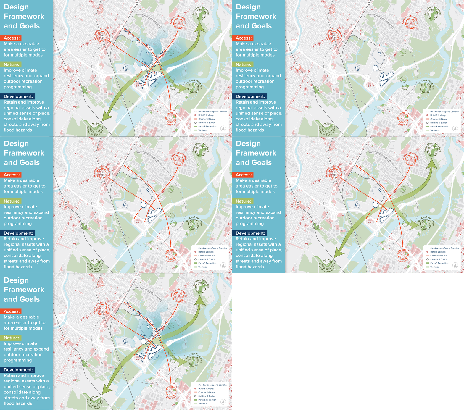
Large-scale framework goals focus on nature, access, and development.
Nature
Utilize the site to connect existing parks and fragmented wetlands. Improve ecological health and climate resilience, and expand outdoor recreation programming.
To do this, we should build out the Meadows Path as originally proposed by the NJSEA, establish a Climate Reserve anchor piece at the Sports Complex, progressively restoring wetlands from areas devoted to surface parking, and adding outdoor active recreation to the site.
Access
Make a desirable area easier to reach via multiple modes of transportation.
Provide greater access to the site by redesigning the main roadways into a network of streets for cars and people, and establishing greenways through selected wetlands and across bodies of water that connect to population centers.
Development
Preserve and enhance existing venues with a unified sense of place. Consolidate development along streets and away from areas prone to future flooding.
The Stadium, Mall, and Racetrack would benefit from concentrating new development along the higher elevation street corridors, which would not only minimize exposure to flood risks but also create a more vibrant, contiguous campus of activity.
These design strategies build upon many of the District-wide “Systems Plan Objectives” outlined within the 2020 NJSEA Master Plan:
System 1: Natural Environment
Objective 1: Preserve & protect existing natural areas, habitats, and other open space
Improve the connections among the District’s habitats and trails, thereby reducing fragmentation
Improve active and passive recreation opportunities, with access available equally to all citizens of the District & surrounding communities
Objective 2: Manage & restore the wetlands, waterways, and other natural resources of the Meadowlands District
Create interconnected networks of open spaces along the river network by creating and connecting greenways
Minimize the amount of impervious surfaces that contribute to flooding
System 2: Economic Development
Objective 3: Cultivate a sense of place unique to the District
Promote greater place recognition of the Meadowlands District as a desirable location to work, play, and live
Improve connectivity among commercial, educational, and cultural facilities and activities, including the Meadowlands Sports Complex, and improve accommodation of pedestrians, bicyclists, and transit users
System 3: Transportation
Objective 4: Encourage the use of public transit within a cohesive and integrated multi-modal transportation system
Promote efficient access to cultural, commercial, environmental, employment, and residential centers in the District
Encourage the use of alternative transportation modes, such as public transit (rail and bus), shuttle service, ridesharing services, bike sharing, and walking to reduce traffic within the District
Objective 5: Promote safe & efficient pedestrian and bicycle circulation
Promote “complete streets” principles through the creation of dedicated pedestrian areas and safe pedestrian linkages among public transit, employment centers, housing, services, and open space
Encourage the development of waterfront esplanades
Conceptual Design

RPA’s Destination Meadowlands 2050 is a conceptual design that translates these framework goals into a cohesive vision. We reimagine the complex as a more consolidated, active campus that incorporates ample greenspace. This vision consolidates uses along multimodal street networks to create placemaking opportunities, enhance existing facilities, support ecological recreation, and enable climate adaptation.
A new activity corridor would serve as the central spine, linking American Dream Mall, MetLife Stadium, and the Meadowlands Racetrack along an east-west route. Significant portions of the site would be restored to wetlands, while the green corridor would feature zones dedicated to active recreation.
Additionally, the vision includes a network of greenways that provide visitors with access to explore the wetlands. These natural spaces would significantly enrich the visitor experience, fostering a deeper appreciation for the unique environment of the Meadowlands and integrating harmoniously into the broader Climate Reserve initiative.
Streets and Walkability
Rather than a conglomeration of highways, interchanges, parking lots, and two pedestrian bridges, redesigned roadways forming a street grid would better connect existing programs and alleviate known bottlenecks in on-site circulation. This approach would also help to transition the large-scale venues into a more human-scaled experience.
A key element of this redesign is reconfiguring Route 120, which currently acts as a barrier between the mall to the stadium. The goal is to create a safe, multi-modal corridor that accommodates both vehicles and pedestrians. Route 120, stretching just two miles long, serves primarily as an access road for the Sports Complex rather than a thoroughfare. Therefore, redesigning the junction with Paterson Plank Road into a standard intersection with traffic lights rather than a highway interchange would improve safety and accessibility. Although this route facilitates some truck traffic connecting to the NJ Turnpike, Route 17, or Route 3, there are alternative routes that could bypass the Sports Complex, minimizing congestion.
The NJSEA has categorized areas to the north of the stadium along Paterson Plank Road and Washington Avenue as “redevelopment areas,” indicating rising development interest, particularly for new hotels and warehouses. By extending street redesign efforts along off-site corridors - north along Washington Avenue and east-west along Paterson Plank Road - we could create safe - and legal - access for pedestrians and cyclists from nearby accommodations.


A dedicated street connects American Dream Mall and MetLife Stadium
Consolidated Development
Development should adopt a consolidation approach that enables future climate adaptation and flood risk reduction. Consolidation along the Route 120 street corridor is ideal for three main reasons. Firstly, designing buildings with strong street frontages enhances walkability and urban design, making it more appealing for visitors to walk around. This also includes rebuilding a new stadium on-site once the current MetLife Stadium’s lifespan approaches its end. Secondly, it reduces sprawl, which is particularly important for Meadowlands wetland ecosystems. Lastly, the land around Route 120 and Paterson Plank Road sits at a higher elevation, ranging from 10 to 20 feet above sea level, making it less vulnerable to flood hazards and future sea-level rise compared with the rest of the district, which has lower elevations.


Meadowlands Ecology Center, the new greenway, and wetlands weave through new development.
As part of the Fourth Regional Plan’s proposal for a Meadowlands National Park, RPA suggested that transit within the Sports Complex could support more mixed-use development. Similarly, this design envisions new mixed-use development organized around a walkable street grid that connects to important existing corridors. Two prominent developments: a revised Meadowlands Convention Center proposal, adjusted to be a piece of the newly articulated mall-to-stadium axis street, and a new Meadowlands Ecology Center, an additional facility supporting eco-education and recreation within the natural Meadowlands. Additional mixed-use development should align with the overarching goal of creating a sustainable recreational hub. While adaptable flat-plate-structured parking could be incorporated into developments, it is essential that ground-floor spaces prioritize active uses to foster a lively and engaging streetscape.
Parking
Roughly 330 acres (57%) of the 580-acre site is allocated to underutilized surface parking, which not only diminishes the site’s sense of place and hinders walkability but also exacerbates flooding issues due to the extensive impermeable surfaces that fragment local habitats. This proposal drastically reduces surface parking on the south and west sides of the stadium, in favor of wetland restoration and outdoor recreation zones. We suggest a gradual transition from surface parking to structured garages to allow for more efficient land use. In the meantime, the remaining surface parking should be sustainably retrofitted to improve permeability by incorporating bioswales, permeable paving, and native landscaping. The structured parking facilities should be designed as adaptable flat-plate garages, providing flexibility for future repurposing.


Former parking lot transformed by wetland restoration and the addition of outdoor recreational opportunities
Strategically locating garages among new developments with active ground floors would create engaging spaces and promote pedestrian activity. The observation that many parking spots remain empty on NFL game days, coupled with the extreme reduction in available parking during the World Cup, indicates a rethinking of the auto-centric status quo and that a significant decrease in parking is feasible. To further reduce the demand for on-site parking, the Sports Complex could build upon existing and planned transportation options including the Meadowlands Rail Line, Port Authority Bus operations, optimized rideshare drop-offs, and new Transitway bus services. Additionally, creating greenways that connect to nearby communities would encourage more sustainable transportation to the Sports Complex.
Greenways
An essential aspect of making this an anchor point for the future Meadowlands Climate Preserve is providing places where visitors can access and engage with the natural Meadowlands. This proposal builds out the visionary Meadows Path, a 25.5-mile pedestrian trail along the western bank of the Hackensack, and envisions a new segment that weaves through the Sports Complex with a series of branching trails. Additionally, the greenway around the Sports Complex should extend to connect additional communities to the complex and ecological recreation opportunities.


Greenway across the Hackensack from Secaucus’ Trolley Park to the Sports Complex
These extensions include a bridge across the Hackensack River, connecting to Secaucus. This route would replicate the original path of the historic Paterson Plank Road river crossing and join the Secaucus Greenway at Trolley Point Park. A segment of this greenway branches off to connect with nearby River Barge Park and Marina, a public boat launch and departure point for eco-cruises. To the north of the stadium, a new elevated crossing over Walden Swamp and Berry’s Creek Canal would provide a direct link along East Union Avenue to the Rutherford NJ Transit Station. As stated in the 2004 District Master Plan, “Greenways provide continuous bands of open space by linking areas of development to natural areas. They offer unique experiences, combining recreational opportunities, alternative transportation routes and a connection to nature”.
It is important to acknowledge that certain greenway routes, especially those involving water crossings, present feasibility challenges. These include compliance with navigable waterway regulations, securing necessary clearances, and addressing the presence of sensitive or contaminated wetlands. While these proposed routes represent optimal connections, flexibility in alignment will be needed. Decision-makers should consider alternative routes that improve access and connectivity while addressing these practical constraints.
We have outlined a general phasing approach for these design strategies from the present through 2050 and up to 2100. Rather than prescribing a fixed sequence, this framework emphasizes priorities, allowing for adaptation as future conditions evolve.

General phasing approach to this bold vision.
Immediate Steps
To kickstart our 2050 vision, immediate priorities should focus on redesigning Route 120 and Paterson Plank Road to ensure the safe passage of pedestrians, cyclists, and vehicles. Following this, a consistent street grid should be integrated into future development plans to enhance clarity and walkability throughout the area. Additionally, establishing a direct “activity corridor” linking the stadium to the mall at street level is important for unifying the site’s programs. Restoration of wetlands should commence alongside sustainable retrofitting of underutilized parking lots located farthest from the stadium, particularly those at the highest risk of flooding. While the specific impacts of sea-level rise are uncertain due to varying emission scenarios and the possible implementation of flood mitigation infrastructure, even slightly elevated areas remain a wise choice for long-term investments and sustainable lifespans.
Vision for 2050
To progress toward the 2050 vision, focus should be on consolidating and intensifying development in higher-elevation locations and along the primary corridors and street grid. Consolidation around Route 120 and Paterson Plank Road would reduce flood exposure, as the area generally sits at a higher elevation, ranging from 10 to 20 feet above sea level, making it less vulnerable than the rest of the site. Strengthening the activity corridor with supportive uses, creating greenways, and establishing connections to Secaucus and Rutherford are also critical. The train station should be strategically adjusted to enhance valuable east-west connections. Additionally, given that the average lifespan of American stadiums is around 35 years, it is likely that MetLife Stadium will be considered for significant updates or replacement around the mid-2040s, as was done for the move from Giants Stadium to MetLife Stadium. Future development should be designed to allow flexibility in planning a potential new stadium.
Onwards to 2100
The feasibility of this design’s evolution from the present day to 2100 will largely depend on which sea-level-rise projections materialize, as well as restructuring existing land-use agreements with the various tenants in the sports complex. As sea level rises and flood risks intensify, we could expect further consolidation of development, and the incorporation of eco-recreational uses within the larger Climate Preserve would be impactful. Taking a proactive approach would better prepare for the changes ahead. In this final phase, the new stadium rebuild is likely to occupy the original Giants Stadium’s footprint, aligning with consolidation principles that enable placemaking and reduce flood exposure.
Conclusion
Destination Meadowlands 2050 presents a framework for policymakers and the public to consider, rather than a prescriptive design, offering a vision for how one of the region’s most recognizable destinations could evolve to meet the challenges and opportunities of the coming decades. By better integrating the Sports Complex with the surrounding wetlands, the Meadowlands could truly become a place where recreation, entertainment, resilience, and ecological stewardship work in concert instead of competing for attention. Building on decades of conservation, investment, and planning, this vision demonstrates that by strengthening the connections between these assets and embracing the Meadowlands’ role as a critical resilience landscape, the district has the opportunity to become a more accessible, adaptive, and distinctive destination for generations to come.
As part of its 2026 Richard Kaplan Fellowship, RPA developed a design for the Meadowlands Sports Complex in New Jersey aimed at enhancing its connectivity to the surrounding wetlands and communities, while also guiding its transition towards future resilience.
Appendix
-
- General Workflow
ArcGIS Pro was employed for mapping and analysis. For finalizing the maps in post-production, we used Adobe Illustrator. Renders were created using a combination of Rhino, Enscape, Photoshop, and Illustrator.
For writing purposes, the authors utilized Grammarly™ for grammar and style corrections.
- Main Data Sources
2020 Hackensack Meadowlands District Master Plan, New Jersey Sports and Exposition Authority.
New Jersey’s Rising Seas and Changing Coastal Storms: Report of the 2025 Science and Technical Advisory Panel. Rutgers, The State University of New Jersey. Prepared for the New Jersey Department of Environmental Protection. Trenton, New Jersey.
Urban Footprint
- General Workflow
-
Established in 1945 by philanthropist and businessman Jacob Merrill Kaplan, the Fund has, since its inception, been committed to visionary innovation. Over its 80-year history, the Fund has devoted $300 million to propel fledgling efforts concerning civil liberties, human rights, the arts, and the conservation and enhancement of the built and natural worlds.
With generous support from The J. M. Kaplan Fund, Regional Plan Association has established an endowed chair in honor of Richard Kaplan, a long-serving board member, inspiration, and friend. The Richard Kaplan Chair for Regional Design provides dedicated resources for a prominent urban designer to pursue innovative research and creative planning for the New York metropolitan region.
During his long association with RPA, Richard Kaplan supported diverse projects, from the seed money to create the Alliance to Rebuild Downtown New York and the Governors Island Alliance to a fact-finding trip to Copenhagen for the City’s Planning Chair and DOT Commissioner, which yielded bold plans to remake New York City’s streets and public spaces for pedestrians and bicyclists. Richard’s devotion to outside-the-box thinking, his towering ambitions, and his willingness to challenge the status quo has and continues to inspire RPA’s design initiatives in the tri-state region.
Acknowledgements
Authored by

Special thanks to RPA staff who provided expertise, guidance, and support:
Rob Lane, Senior Fellow for Urban Design
Zoe Baldwin, Vice President for State Programs
Rob Freudenberg, Vice President for Energy & Environment
Moses Gates, Vice President for Housing & Neighborhood Planning
Marcel Negret, Director of Land Use
Funded By
- The JM Kaplan Fund
Related Reports
557