
This video was produced by Nate Dorr and RPA and aired during the RPA Centennial Assembly on May 6, 2022 to commemorate the organization’s 100th anniversary.
The First Plan in Context
The New York-New Jersey-Connecticut metropolitan region was a thriving center for commerce, manufacturing, and culture at the turn of the 20th century. The population of the metropolitan region grew from approximately 5.4 million in 1900 to 9 million by 1920. By 1925, well over a third of New York City residents were immigrants.
But the living conditions lamented by Jacob Riis in 1890 had not improved much by the 1920s. Poverty and overcrowding were still endemic in many Manhattan neighborhoods. New York’s booming industries helped the economy grow rapidly, but had become a burden on city life, as the scale of the facilities necessary for shipping, warehousing, and manufacturing grew, along with the ancillary noise, traffic and air pollution. Freight shipped in and out of New York City ports increased by 50 percent from 1900 to 1925.


Several new technologies developed that changed the urban landscape in significant ways. A network of underground and elevated subways was rapidly emerging across the city. New long-distance railroads were built to connect Manhattan with upstate New York, Connecticut, Long Island, and New Jersey, including some areas that had previously been accessible only by ferry. Private automobiles were becoming more affordable, just as more durable road surfaces were invented and applied to city streets. These new transportation technologies were changing the geography of the region by significantly expanding the area within a reasonable commute of downtown.
New York City and the region were growing with little but market forces at work. The Committee on a Regional Plan of New York and Its Environs introduced rationality to the region’s development and was intended to give residents a better quality of life.
From Chicago to New York
The first Regional Plan had its roots in Chicago. The 1909 Burnham Plan for Chicago helped reshape the city and was a major influence on the field of urban planning. One of the supporters of the 1909 Plan was Charles Dyer Norton, a member of the Commercial Club in Chicago. It was this success in Chicago that inspired Norton to launch a comparable effort in New York.

Norton was appointed Chairman of the Advisory Committee for the City Plan in 1914 by George McAneny, President of the Board of Alderman. Norton and the Committee reviewed the state of urban planning in New York and issued a report. They also discussed organizing a citizens’ group to finance and develop a plan independently of municipal officials. Norton recognized that a plan for New York City that failed to take into account the communities surrounding it wouldn’t succeed.
“No plan of New York will command recognition unless it includes all the area in which all New Yorkers earn their livelihood and make their homes.”
—Charles Dyer Norton, November 27, 1915

Supported By The Russell Sage Foundation
Efforts to create a New York City plan stalled in 1916. Undaunted, Charles Dyer Norton took his ideas to the Russell Sage Foundation, an organization dedicated to improving quality of life, with a significant portfolio allocated for the betterment of the New York region. Norton was a Trustee of the Foundation, and in 1919, he recommended that Russell Sage organize and finance a plan for New York and its environs.
Two years later, in 1921, the Russell Sage Foundation created the Committee on the Plan of New York and its Environs and appointed Norton as Chairman. The Committee commissioned preliminary surveys of the region by Nelson Lewis, former Chief Engineer of New York City, as well as an analysis of zoning laws by Edward Bassett, former Chairman of the Zoning Commission of New York. The first official Committee meeting was held on May 10, 1922 and included attendees such as Elihu Root, Lillian Wald, Charles Dana Gibson, Mrs. August Belmont, and Herbert Hoover.

“The lack of adequate open spaces, of playgrounds and parks, the congestion of streets, the misery of tenement life and its repercussions upon each new generation are an untold charge against our American life. The moral and social issues can only be solved by a new conception of city building.”
— Herbert Hoover, First Meeting of the Committee on the Plan of New York and its Environs, May 10, 1922

Years in the Making
Unfortunately, Charles Dyer Norton did not live to see the first Regional Plan published. He died in 1923, shortly after the project officially began.
The Committee of the Regional Plan appointed Frederic A. Delano as Chairman and hired Thomas Adams as General Director of Plans and Surveys. Over the next few years, Adams and his team painstakingly analyzed the population density and distribution of the New York metropolitan region, its economy and industries, and its topographical and physical conditions, including highways, public transportation, parks, and open spaces. Zoning codes, land rights, and existing municipal plans were reviewed. Living conditions and impacts on the health and welfare of residents were also researched.
From 1927 to 1929, a series of technical volumes were published as precursors to the first Regional Plan.
- Vol I: Major Economic Factors in Metropolitan Growth and Development
- Vol IA: Chemical, Metal, Wood, Tobacco, and Printing Industries
- Vol IB: Food, Clothing, and Textile Industries, Whole Markets and Retail Shopping and Financial Districts
- Vol II: Population Land Values and Government
- Vol III: Highway Traffic
- Vol IV: Transit and Transportation
- Vol V: Public Recreation
- Vol VI: Buildings: Their Uses and The Spaces Around Them
- Vol VII: Neighborhoods and Community Planning
- Vol VIII: Physical Conditions and Public Services
Presentation of the Regional Plan
George McAneny, now President of Regional Plan Association, presented the first volume of the Regional Plan on May 27, 1929 to representatives of over 400 communities and organizations. Speakers included Lillian Wald of Henry Street Settlement, William Collins of the American Federation of Labor, as well as public officials from New York, New Jersey, and Connecticut.

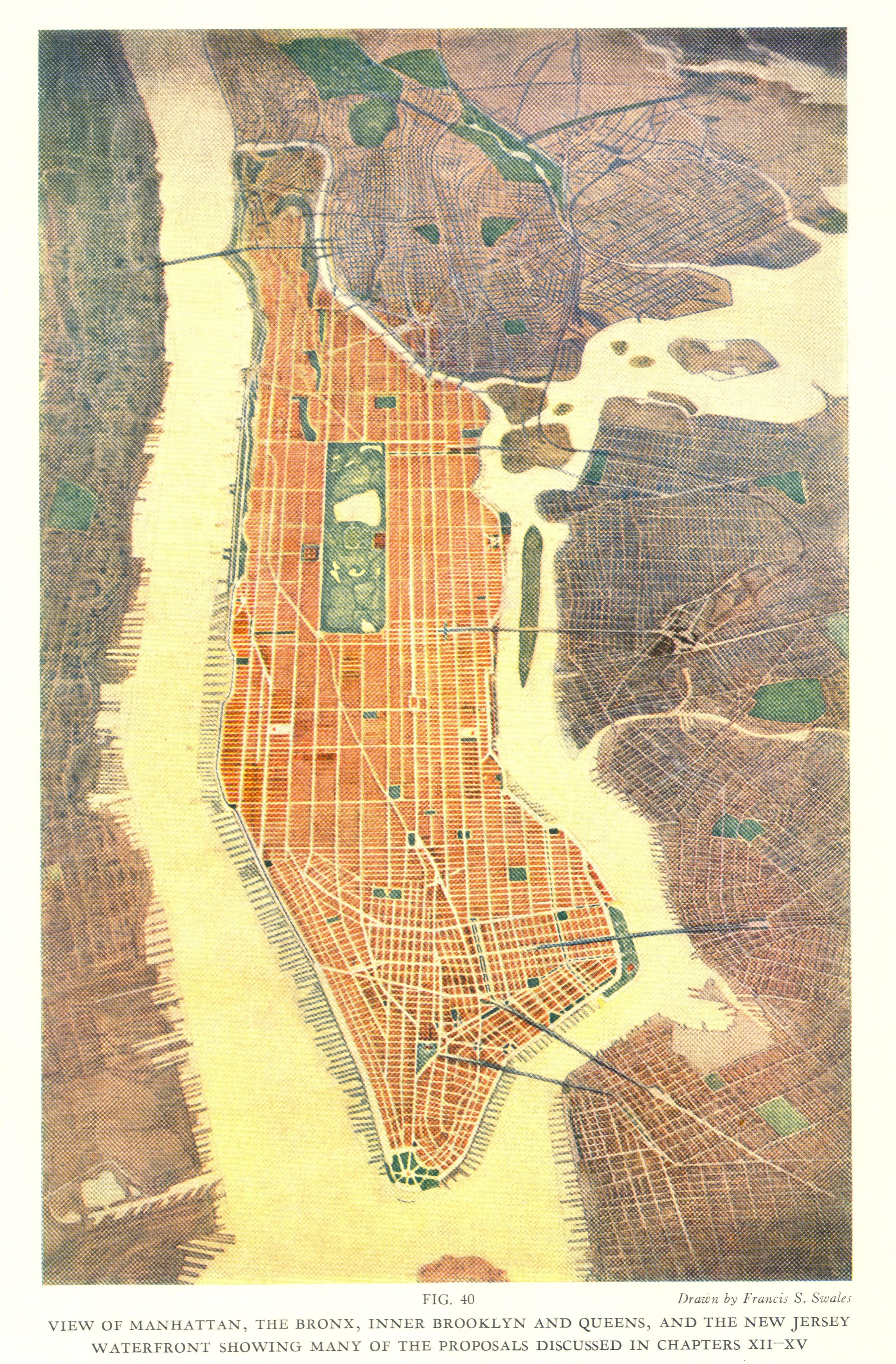
The First Volume of the Regional Plan proposed an elaborate network of highways, railroads and parks, along with residential, commercial and industrial centers, as the foundation of the physical and social development of the region. It also identified specific natural areas that could be acquired for public use.
The Second Volume focused on urban design, including the relationship of development to open space, fitting buildings to streets, and pedestrian ways separated from vehicle traffic.
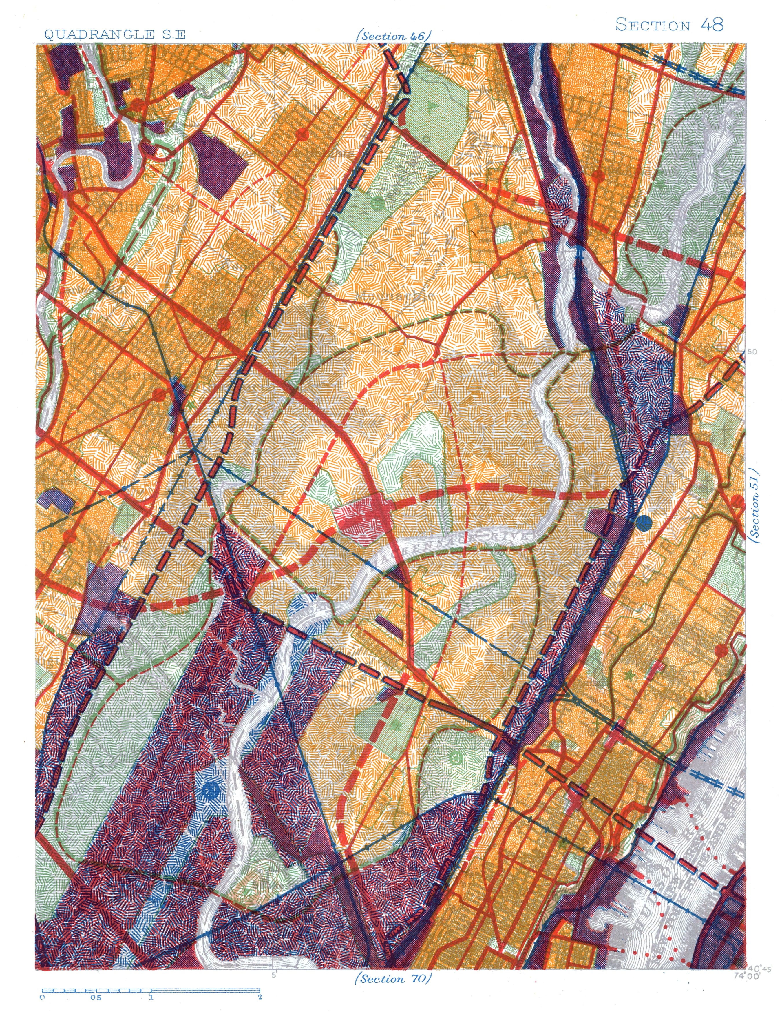
Mapping the Region
The first Plan produced definitive maps of the New York-New Jersey-Connecticut metropolitan area. They contained analyses of demographics, population distribution, economic conditions, land utilization, transportation, natural features, and other characteristics of the region, at a time when such data was difficult to come by.


The first Regional Plan presented a new way of thinking about development and governance, and inspired a whole movement of regional planning in the country and abroad. It put forth the idea that the creation of vibrant, livable, and sustainable urban communities did not stop at political boundaries. It built strong support for the principle that cities could improve their quality of life and efficiency as they grew and prospered, but only if they planned ahead for growth. As the world’s first long-range metropolitan plan, it inspired other cities around the world to create their own comprehensive, region-wide plans, such as the Abercrombie Plan for London in 1944.
Many proposals from the first Regional Plan were implemented in the 1930s and 1940s. During the Great Depression, when Franklin Delano Roosevelt needed ideas for public works programs to help unemployed workers, he turned to the first Regional Plan. The Plan inspired millions of dollars in infrastructure and city-building projects. RPA’s advocacy also led to the acquisition and preservation of large areas of open space for recreation throughout the region. In 1989, the first Regional Plan was designated a National Planning Landmark by the American Planning Association for its contributions to the field.

But the first Plan was not without its critics or its flaws. Its growth assumptions and recommendations to focus development in Manhattan were fiercely criticized by some leading planners. Most vocal among them was Lewis Mumford, who suggested that stronger efforts should be made to restrain development and de-concentrate New York’s urban core.
Much of the first Plan’s proposed highways, bridges, and parks were achieved in large part through the efforts of master builders such as Robert Moses. Some projects, like Orchard Beach in The Bronx, were seen as net positives. However, several projects had negative impacts on the surrounding communities, or the potential for it. For example, in the 1930s, RPA opposed Robert Moses’s proposal to build a bridge from Manhattan’s Battery Park to Brooklyn. Moses pilloried RPA and its Regional Plan in the press, but his bridge plan did not succeed.
On the subject of blight, the first Regional Plan suggested policy solutions, such as public housing projects and slum clearance through eminent domain, which would have repercussions on low-income communities. Additionally, the first Regional Plan’s proposed highway network helped enable sprawl after World War II, a challenge which was addressed in subsequent Regional Plans.
A More Connected Metropolitan Area
A goal of the first Regional Plan was to provide access to more of the region and give options for living beyond the overcrowded core. The concept of metropolitan planning driven by transit and limited-access highways created a blueprint for later development in the region. The construction of the region’s highway and parkway network followed the first Regional Plan closely. Between 1928 and 1940, more than a third of the first Plan’s 2,548-mile highway program was completed or in progress. By the time of RPA’s 25th anniversary, more than 400 miles of the arterial parkway system was developed, including the Belt Parkway, Henry Hudson, and East River Drive.


The George Washington and Verrazano-Narrows Bridges
The proposed network of highways led to the relocation of the planned George Washington Bridge from 57th Street to 178th Street in the 1920s. RPA understood the bridge would primarily be used for traveling through the region, and should therefore avoid the congestion of Midtown. This also prevented a limited access highway from being built across the southern boundary of Central Park, which would have separated the Park from Midtown. The metropolitan loop proposed in the first Regional Plan was completed in the 1960s with the construction of the Verrazano-Narrows Bridge, which connected Staten Island and Brooklyn.


Preserving Land and Doubling Park Space
The first Regional Plan identified natural areas that could be acquired for public use. The Plan was an important factor in the doubling of the region’s park space, as well as the establishment of Garret Mountain Reservation in Paterson, NJ, Great Kills Park on Staten Island, and the Palisades Interstate Park System. In 1933, John D. Rockefeller Jr. offered to transfer 265 key acres on top of the Palisades to the Palisades Interstate Park Commission along the general lines recommended by the first Regional Plan.


Planning for the Future
RPA helped local governments establish planning boards to advise on development decisions. From 1929 to 1939, the number of planning boards in the region increased from 61 to 204. In 1936, the planning commission for New York City was formed. RPA’s chief administrative officer at the time, Lawrence Orton, was one of the first commissioners, and he served in that role for 31 years.


Other Reports in this Series
556