Today New York metropolitan region is already witnessing the early effects of sea level rise. New predictions estimate that our region could see one foot of sea level rise in the next 15 to 20 years.
And despite this severe threat facing the region with its 3,700 miles of tidal coastline, relatively little has been done to address the permanent inundation rising seas will create.
Today RPA released a new report identifying the neighborhoods, employment centers and infrastructure in the New York region that are most at risk of being permanently flooded in the coming decades. The report, Under Water: How Sea Level Rise Threatens the Tri-State Region, outlines the impact that 1, 3 and 6 feet of sea level rise could have on the region and the immediate actions that policymakers and residents should take to protect our region’s most vulnerable places.
Beach communities on the Jersey Shore and Long Island are often the first that come to mind when thinking about areas at risk to rising seas. These barrier beach and back bay communities are also among the most difficult to protect. But the future of some of the region’s urban areas, dense with jobs and critical infrastructure, also hangs in the balance.
Take the New Jersey Meadowlands, for example. Home to over 30,000 at-risk residents, Teterboro Airport, the Secaucus rail station, Giants Stadium, the American Dream entertainment project, thousands of industrial jobs and critical roads and rail lines, the Meadowlands could be inundated at three feet of sea level rise, a possibility as soon as 2080, and requires careful planning today to determine where water can be kept out and how to adapt to permanent flooding where it cannot.

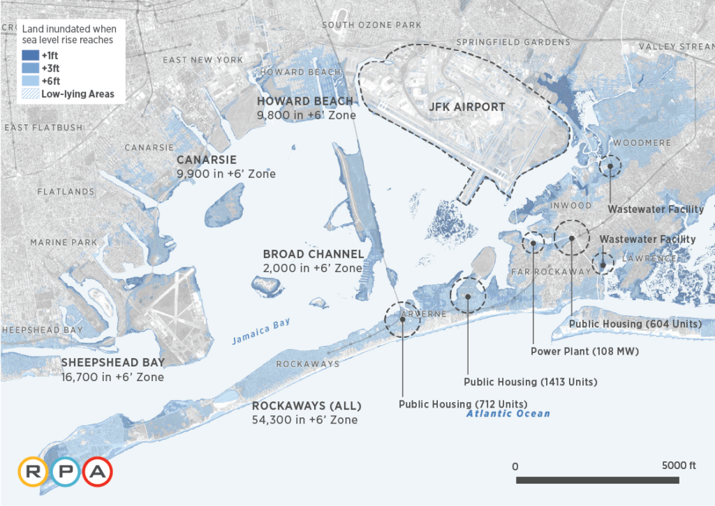
The communities of the Rockaways, Jamaica Bay and Coney Island are among the most threatened in New York City. With 6 feet of sea level rise, a possibility as soon as early next century, much of the Rockaway peninsula could be underwater, Jamaica Bay will have extended its reach deeper into its waterfront communities and more than half of Coney Island’s current population could be at risk of permanent inundation.

In addition to population and job centers, the region’s infrastructure, including its airports and seaports are severely threatened by sea level rise. As little as one foot of sea level rise has the capacity to permanently flood Teterboro Airport in the Meadowlands. With three feet of sea level rise, half of LaGuardia airport could be permanently flooded. Other threatened infrastructure includes Hoboken Terminal, PATH lines and the region’s waterfront wastewater treatment and energy generation plants.

The report warns that action must be taken now to adapt the places most at risk by determining where engineered solutions can best keep water out, where we can try to live with higher seas and how we can begin to phase out new development and retreat from some places over the coming decades.
The study is a component of RPA’s fourth regional plan, A Region Transformed, which will be released in 2017 and will put forth policies and proposals to mitigate climate change and confront its effects.
Immediate actions outlined in the report include:
- Implement the 2015 international Paris agreement to limit future greenhouse gas emissions.
- Include planning and funding for sea level rise in federal, state and local efforts to promote resilience
- Begin dialogue in vulnerable communities about how to best adapt to sea level rise
Read the full report: Under Water: How Sea Level Rise Threatens the Tri-State Region
